Wednesday, October 6, 2010

Isopleths

http://www.google.com.pe/imgres?imgurl=https://blogger.googleusercontent.com/img/b/R29vZ2xl/AVvXsEj5VrUsnse-7GaTzSS2sRooBf6mRdMT40y2d3_ZMMW_1Og_54TE5W4UFuwP4-OODs7jmSplj7nJtpCcPnAY4mv01FBa-G088qbVaJ4Jil7KV-ge2oio_IzGd6U-c_ACaCLo0Nb9bnkhrF9N/s400/isopleths.gif&imgrefurl=http://gmat505.blogspot.com/2010_04_01_archive.html&usg=__nrSVysom9zNHr2jXFE2zVSANS_k=&h=307&w=400&sz=149&hl=es&start=2&zoom=1&um=1&itbs=1&tbnid=LB3-6T1SE6b9AM:&tbnh=95&tbnw=124&prev=/images%3Fq%3DIsopleths%26um%3D1%26hl%3Des%26sa%3DN%26tbs%3Disch:1

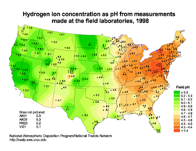
This is an isopleth map of the United States that illustrtates the amount of pH in the country. An isopleth is a contour line that illustrates a variable that cannot be measured at any give point. In this map, we can see that different colors are used to illustrate the amount of pH

No comments:

Post a Comment